The nexus between transportation and land use.

Category: Urban Planning Page 3 of 5

Urbanism and Resort Communities

Sarasota, FL skyline. Source: Patrick Braga via Wikimedia Commons

I’ve spent the better part of last week in Sarasota, Florida, on Lido Key with my family to attend a wedding for my sister-in-law. Much has been written about sprawl throughout Florida or the housing crisis. What interested me was the urbanism I had found near the resort I stayed at, most unexpectedly.

St. Armand's Circle, looking west towards Lido Key.

The urbanism I’m speaking of was found on Lido Key and neighboring St. Armand’s Key. John Ringling (of Ringling Bros. fame) and Owen Burns purchased Lido Key, St. Armands Key and neighboring Bird Key in the 1920s and began a development scheme which eventually failed in the 1929 stock market crash. St. Armand’s Key has in its center, Harding Circle, shopping district oriented around a beautiful roundabout, which has been recognized on the National Register of Historic Places.

In the pictures, you may notice several features celebrated in new urbanism and planning circles alike: roundabouts, landscaped sidewalks and pedestrian treatments, all imposed on a grid street pattern.
These types of urban environments in resort communities are few and far between. I treasure spending time in these environments.

St. Armand's Circle pedestrian crossing. Source: Thoralf Schade


See how the landscape treatments separate cars from pedestrians? This allows more intensive pedestrian uses of the sidewalk like this cafe. Source: winterwhiteiris

Smart Meters and Dumb Deals: What Chicago is missing out on.


Source: Jalopnik.com

Much has been said about the parking meter fiasco and how badly Chicago has been burned. I don’t have any more to add. Rather, I’d like to focus on missed opportunities in parking technology – opportunities at the meter that support urbanism and can generate real revenues for the city. Principally, this opportunity revolves around variable pricing policy.

While cars may be a part of urban life, free (or under-priced) parking does not have to be. Donald Shoup, author of the preeminent manual on the topic, The High Cost of Free Parking, states that planners tend to tackle street parking problems by increasing off-street parking requirements. “Rather than charge the right price for on-street parking, cities attempt to require the right quantity of off-street parking,” according to Shoup.

Chicago’s parking meter rates before the lease were low in many areas (they still are likely too low in some places). They were low because cruising and overcrowding of parking were the staples of urban life, particularly in many of the lakefront neighborhoods and downtown. Conversely, we know that if parking were priced too high, vacancies would be an issue. This is simple economics, the supply and demand curve (see below).

The Market Price of Curb Parking. Source: Shoup, VTPI

True market priced parking allow for free parking until an occupancy reaches 85%. This is due to the marginal costs of adding parking is zero, Yet, when demand (occupancy) increases, the marginal cost of adding additional parking increases. Because on-street parking capacity is fixed, costs must rise to meet demand. Thus parking costs should rise. This is what is called variable parking.

A smart parking meter, such as what has been installed in San Francisco, for example, can manage the availability of on-street parking by utilizing smart meters that can adjust prices dynamically, based on demand.

This technology is enabling not just better revolution of parking, but management of parking as well.

The problem with Chicago’s parking meter lease is not just that Chicago no longer controls parking, an important revenue generator in its own right, it is that the City gave up the right to control planning policy on some of the most vibrant land it owns – the streets. The City gave up the right to manage its on-street parking, to further planning goals and livability projects that create complete streets. Such projects might be pop-up cafes, bike lanes, street parades and festivals, all of which can reduce parking supply. And all of which are penalized under the terms of the parking lease.

Pop-up cafe in Manhattan. Source: ecosalon.com

The shame is that at the moment when parking meter technology  is revolutionizing the way cities manage parking, Chicago has turned over almost significant control over to a private company. The shame is that transportation planning is moving towards complete streets policies and Chicago finds itself without the flexibility needed to make its streets more livable and more complete.


CDOT Plan: Reaction

The Chicago Department of Transportation just released its Chicago Forward Action Agenda, which is the department’s strategic plan. You can read a good summary of it over at Grid Chicago and the full plan is available here. The plan has six elements. Here is my immediate reaction to the plan.

Safety

  • Eliminate all pedestrian, bicycle and overall traffic fatalities within 10 years.

I agree that traffic fatalities can be reduced and/or prevent through structural and design changes, but I think only to a point. We can’t control driver behavior. While this is a laudable goal, I don’t see funding to implement the changes that CDOT’s studies may suggest. Definitely not over 10 years. I do, however, appreciate additional study that could lead to small, but immediate safety improvements, particularly for bicyclists and pedestrians.

  • Reduce pedestrian and bicycle crash injuries, each by 50% within 5 years.

Another laudable goal, but what I’d like to have seen in the actions list is (and perhaps this falls under the Complete Streets policy) a re-engineering of the roads to slow down traffic. This could be accomplished through technology like speed cameras, but also through road diets and lane width shrinkage.

Rebuild and Renew

One area that is missing, and kudos for Grid Chicago for asking Gabe Klein about this, is partnerships with the other transit agencies besides CTA. And while I accept that CTA and CDOT have close working relationships for historic, political and practical reasons, the CTA is not the only mode of public transportation in the city. I’d love to see the city partner to improve commuter rail stations, both downtown and in the neighborhoods in as meaningful a partnership as the City has with CTA.

Choices for Chicago

I cannot emphasize enough how happy I am to read that the car “should be a choice, not a requirement.” This is true multimodal thinking! Let’s hope that the plan does not do anything to make it easier to drive in Chicago. It is already easy enough. While not the purview of CDOT’s silo, I would have loved to see an action item stating that CDOT would work with the Department of Housing and Economic Development  on land use and zoning issues that would support transit and bike/pedestrian modes better.

Sustainability

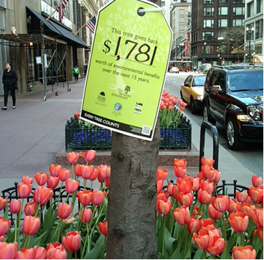
The environmental value of a tree. Source: CDOT

One of the coolest things that I’ve seen around downtown, highlighted in this plan, is the GreenStreets campaign, where the trees have “price tags” that illustrate the environmental value of the tree.

Fueling Our Economy

I think the very first performance measure, to increase activity, sales revenue, and occupancy rates in neighborhood commercial districts, is a fantastic example of breaking out of the silo. This is a problem that will have to be addressed city-wide through multiple agencies. Recognizing that streets can “add value”  to the neighborhoods means that you begin looking at streets in “complete” terms, as in how can a street serve multiple modes simultaneously?

This is it, for now. I’m happy to see CDOT embark on a strategic plan with a clear vision for what Chicago should be. I cast a critical planners eye, but I hope to convey that this is, however imperfect, a wonderful product. Now let’s see the implementation plan.


Speed Cameras and Complete Streets

I’d like to add a little more to the comments I posted on Grid Chicago regarding the speed cameras ordinance passed by the City of Chicago earlier this week.

As usual, the guys at Grid Chicago did an excellent job of reporting on the legislation and what it will (or won’t) do and I don’t intend on covering that. What I do think is important to highlight is the fact that too many streets in Chicago are built so wide as to encourage speeding. In my northwest side neighborhood of Jefferson Park, Milwaukee Avenue gets so wide north of the UP Northwest Line bridge that it is virtually impossible to travel the speed limit (30 MPH) without getting run off the road.

[mappress mapid=”1″]


This type of road cross-section is what Charles Marohn calls a “complete road.” And it is designed for the 45 MPH world that is an engineering, fiscal, and urban design failure.

This is the problem with Milwaukee Avenue and for many of the major four lane arterial streets in Chicago. They are designed for quick movement of cars. Thus, a 30 MPH speed limit, which is the speed limit in Chicago where not posted otherwise, is a joke for cars. And it is dangerous for pedestrians and bicyclists.

Seattle: N. 130th St. - Before Source: Complete Streets @ flickr

Seattle: N. 130th St. - After Source: Complete Streets @ flickr


If we’re really concerned about safety and about reducing pedestrian, bicycle and auto injuries and fatalities in this city, speed cameras are not the answer. Better design is. This is what I would recommend:

Reduce the width of the lanes to 10′ widths, perhaps even dropping a lane. Most of Milwaukee Ave. south of the UP-NW line into downtown is two lanes. This frees up room for the bike lane. In addition, there will be room for a median with protected pedestrian crossings. According to the National Complete Streets Coalition:

Complete streets reduce crashes through comprehensive safety improvements. A Federal Highway Administration review of the effectiveness of a wide variety of measures to improve pedestrian safety found that simply painting crosswalks on wide high-speed roads does not reduce pedestrian crashes. But measures that design the street with pedestrians in mind – sidewalks, raised medians, better bus stop placement, traffic-calming measures, and treatments for disabled travelers – all improve pedestrian safety. Some features, such as medians, improve safety for all users: they enable pedestrians to cross busy roads in two stages, and reduce left-turning motorist crashes to zero, a type of crash that also endangers bicyclists.

One study found that designing for pedestrian travel by installing raised medians and redesigning intersections and sidewalks reduced pedestrian risk by 28 percent. Speed reduction has a dramatic impact on pedestrian fatalities. Eighty percent of pedestrians struck by a car going 40 mph will die; at 30 mph the likelihood of death is 40 percent. At 20 mph, the fatality rate drops to just 5 percent. Roadway design and engineering approaches commonly found in complete streets create long-lasting speed reduction. Such methods include enlarging sidewalks, installing medians, and adding bike lanes. All road users – motorists, pedestrians and bicyclists – benefit from slower speeds

Complete streets encourage safer bicycling behavior. Sidewalk bicycle riding, especially against the flow of adjacent traffic, is more dangerous than riding in the road due to unexpected conflicts at driveways and intersections. A recent review of bicyclist safety studies found that the addition of well-designed bicycle-specific infrastructure tends to reduce injury and crash risk. On-road bicycle lanes reduced these rates by about 50%.

Enhanced by Zemanta

Olympic Games and Transport Infrastructure: An Analysis

Olympic Games construction site A birds eye vi...

This is the last in a four-part series on the Olympic Games as a catalyst for urban, and specifically transportation, development. In Part I, we explored  the background of how the Games are administered at the local level. Part II examines the growth of the Olympic Games and how it became a catalyst for general urban development. And Part III examined transport infrastructure in relation to the Games, with a closer look at London’s preparation for the upcoming 2012 Summer Olympics. In this last post on the Olympic Games, we’ll analyze what this all means for the Olympic Games and for the host cities themselves.

Analysis

A London Underground train decorated to promot...

A London Underground train decorated to promote London's Olympic bid. (Photo credit: Wikipedia)

Transportation infrastructure has become essential component of successfully hosting a mega event such as the Olympic Games. Due to the large volume of spectators and athletes, logistics problems become complex as organizers seek to make the Games as efficient as possible in an urban transport network that is often inefficient. Because of each city’s unique history and urban form, the impacts of the Games on transport development differ.

Additionally, it becomes clear that when examining previous Olympic Games over the last few decades, many of the host cities have tried to choose sites which were underutilized or brownfield sites. Often these sites are the only large sites within the central city that is suitable for Olympic venues. Additional incentives for this seem to be a regeneration of central city areas like we have seen at Homebush Bay in Sydney, Helliniko Airport in Athens, and Stratford in London. In all cases, some transportation infrastructure may have been in place, yet it was underutilized or inefficiently serving the site.

In Sydney, host of the 2000 Summer Olympics, the Games were a significant catalyst for urban infrastructure development around the region. Beside the direct investments made for the Games, the indirect investments prior to or after the Olympic Games were expedited. These improvements included better transport connectivity and a major capacity expansion scheme to its airport, Kingsford Smith International, as well as capacity improvements at its main rail hub, Central Station. All together, direct investment in transport infrastructure as a result of the Olympic Games was A$370 million ($384 million), while indirect investment was approximately A$3 billion ($3.1 billion).

Athens, host of the 2004 Summer Olympics,  had transport issues that were significantly different from Sydney’s. Athens is an ancient city with a dense urban form. It also did not have much of the tertiary structure that is necessary to handle the increased demands of an Olympic Games. Due to the city’s urban form and a lack of large parcels of available public land, Athens had to spread out its Olympic venues across the Attica Plain. This was problematic due to the notorious traffic congestion facing Athens and the little public transport infrastructure within the city. Thus, by agreeing to host the Olympic Games, Athens embarked on a scale of transport investment that had not been seen since Tokyo in 1964. The direct and indirect investments in transport infrastructure included a new international airport, two metro lines, a tram system, and a suburban railway. All of these infrastructure improvements were built with the goal of making transport more efficient during the Olympic Games. In total, direct investment as a result of the Olympic Games in transport infrastructure was over 2.86 billion euro ($4.5 billion).

London’s model for urban development was similar to Sydney. It has an area ripe for regeneration at Stratford. London also has transport connections near the site of the Olympic Park but needed significant investment in public transportation infrastructure to make the site accessible. The Olympic Village is also adjacent to the Olympic Park like in Sydney. However, the similarities between the two cities end here.

London has a much more complex set of existing transport infrastructure in place. The key for London is to arrange and maximize the efficiencies of the transport infrastructure to serve the Games and the regeneration afterward. For London is unique in the case studies to be simultaneously regenerating the area around the Olympic Park in Stratford.

It is difficult to estimate how much the London Olympic Games will eventually cost. Cost overruns have already plagued the Games and are further anticipated. Given what is now reported, however, direct investment by the Her Majesty’s Government in transport is anticipated to be approximately £900m ($1.8 billion). Indirect investments in transport, particularly at Stratford International and other public transport services, both public and private, are estimated at £1bn ($2 billion) annually from 2007 through 2012.

Legacy

A legacy of the 1988 Summer Olympics in Seoul, South Korea. The Olympic Bridge over the River Han.Source: yarra 64 @ Wikimedia Commons.

Over the past several decades, almost all Olympic host cities have used the Games as a catalyst for massive urban regeneration. The legacy of hosting the Games includes physical and economic effects that are left following the Games that would otherwise not have occurred without the Games.

Structural change to the host city’s urban infrastructure can provide the host city with a once in a lifetime opportunity for massive urban development. The improvement in transport infrastructure and efficiency makes the city more efficient and competitive, drawing industry, income, and jobs to the Olympic host city. It can spur regeneration like it has in London (5,000 homes and a town center). Or it can open up new areas for development (new international airport in Athens). Either way, the trend is toward larger and more significant investment in infrastructure, using the Olympic Games as a catalyst toward infrastructure investment and regeneration.


Page 3 of 5

Powered by WordPress & Theme by Anders Norén