Transport Nexus

The nexus between transportation and land use.

Suburban Poverty

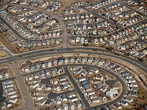
Suburban development in Colorado Springs, Colorado

Suburban development in Colorado Springs, Colorado (Photo credit: Wikipedia)

Veering off a little from previous topics, I’d like to discuss the issue of suburban poverty, which has been in the news lately, and what it means for metropolitan regions and transit service providers.

The impact of the Great Recession will be felt  for decades and some of the long-term problems are only now just beginning to be understood. The foreclosure crisis, high unemployment, and a collapse in government revenues have had quite an impact on the built environment. This has serious ramifications, particularly for suburban areas. To wit:

  • The largest and fastest growing population of poor people are in the suburbs.
  • The social safety net of the suburbs was weak to begin with and is now in tatters.
  • Transit service is a function of population density and urban form, of which the former is low in the suburbs and the latter generally does not encourage pedestrian activity of any kind in the suburbs.

Thus, we have the makings of a development pattern similar to continental European cities where the wealthy inhabit the inner core and the poor inhabit the outer areas of the metropolitan region. This is somewhat hyperbolic, but not beyond the realm of possibility. As we are observing, the millennial generation prefer cities, abhor cars and are attracted to the metropolitan regions where transit and rental apartments are in abundance. It may be that low density suburbs are the “loser” in the aftermath of the Great Recession. 

suburbs
Twilight of the suburban experiment? (Photo credit: maureen_sill @ flickr)

As this trend plays out, we’re already seeing what has been happening to the suburbs and how to grapple with this issue will be a profound one for my generation. Because the suburban environment was built on the assumption of never-ending growth, it cannot cope when that growth stops. Thus we see over-saturated retail commercial vacancies, massive subdivision foreclosures and an overbuilt infrastructure that small taxing bodies can never afford to maintain, not to mention replace.

How transit will survive and adapt to this market is a good question. Because suburban poverty is rising and the social safety net of the suburbs was never firmly in place (including transit), it remains to be seen what can be done. The inherent difficulties of providing frequent transit service in low density areas was obvious when times were good and is compounded now because, sadly, a population that needs transit most lives in an area where transit is most difficult to provide. Even in cities, transit services are cutting back on budgets, adjusting to the economic climate in which they operate. And most transit services have state of good repair issues so great that adding additional service in areas poorly served or not at all is a low priority at best.

We’re at the tip of the iceberg here in regards to the suburban experiment and suburban poverty is only the beginning. We’re looking at a future where this population becomes increasingly cut off from the world as jobs and people relocate and reorient themselves to a living pattern based on existing transit systems where the car and house with a picket fence is an option, not a necessity. Municipal governments, particularly small suburban ones not connected to larger cities by transit will likely fail under their enormous debt obligations and their infrastructure will really begin to crumble. And the tract houses in the subdivisions named “Orchard Hills” and “Lakewood”? Well, according to Brookings:

those house prices are now below replacement value, meaning the land under the house has no value and the sticks and bricks are worth less than they would cost to replace. This means there is no financial incentive to maintain the house; the next dollar invested will not be recouped upon resale. Many of these houses will be converted to rentals, which are rarely as well maintained as owner-occupied housing. Add the fact that the houses were built with cheap materials and methods to begin with, and you see why many fringe suburbs are turning into slums, with abandoned housing and rising crime.


Supply and Demand in Downtown Residential Parking

Downtown Chicago Building Roundup: North

Downtown Chicago Building Roundup: North (Photo credit: Gravitywave)

I’d like to delve a little bit further into the pernicious effect of parking minimums, particularly as it distorts the market tenets of supply and demand. Seeing an article over the weekend in Crain’s Chicago Business about the decline in parking demand in downtown Chicago residential buildings, I could not avoid beating my favorite drum about the high cost of parking and its negative externalities. Here is the problem, according to Crain’s:

Demand for parking is dropping in downtown apartment buildings. At Lakeshore East, a development of mixed use high rise apartment and condo buildings just north of Millennium Park, south of the Chicago River and east of Michigan Ave., around 40% of renters lease a parking space, down from the developers projection of 55%. This would be fine in a true free market where the developer would assume the risk of overbuilding on parking. However, the City’s zoning code, in its infinite wisdom, requires parking in new residential developments at ratios of 0.55 to 1 space per unit. Thus, the developers initial projection for parking is at the lowest end of the parking ratio in the zoning code and is still over market demand.

Of course, I agree with Matt Yglesias in that the “problem with this regulatory minimum is that it makes it harder for existing buildings to recoup the losses previously incurred through overbuilding of parking.” Because the zoning code won’t allow for pooled or shared parking between buildings, each building must have its own allocated parking. The costs of this parking, of course, get passed onto the occupants of the building indirectly, regardless of whether the occupants have a need for a car.

Because of the over supply of residential parking downtown as mandated by zoning, parking is artificially cheaper than it should be. This, of course, encourages greater auto use in the densest part of the city, the part in which public transportation of various modes operate at a very high frequency practically around the clock. It also encourages the catering of urban design towards the car and away from alternate transportation modes, despite the fact that the alternate transportation modes may make up a larger share of trips in this area.

Ideally what I would like to see in this circumstance is free market pricing for residential parking, or if the zoning will continue to manipulate the market,  parking maximums (for all types of parking). This will allow for shared parking at closer to the true cost of providing that parking. It will also allow the free market to decide what the best use of property is under right and can reduce the cost of development and occupation of residential and other space. Most importantly, removing the parking minimums and over-supply of parking will be supportive of the existing public transportation infrastructure in place downtown, as it is the dominant mode of travel within the area and its externalities are significantly better than the car.

Transport Nexus in the Polish Triangle

Looking southwest from the Polish Triangle

Of great interest to this site is the connection, or nexus, between transportation and land use.  One prominent example of this failure of this nexus is at the southwest corner of Ashland Ave., Division St. and Milwaukee Ave., historically known as the Polish Triangle. Now part of the East (Ukrainian) Village neighborhood, this site is commonly known as the “Pizza Hut” site.

Needless to say, it is an abomination that this site was designed (allowed) in such a way as to maximize the use of the automobile when you have the following conditions present:

  • Access to the CTA Blue Line at Division St.
  • The #70 Division bus (running east-west) stop literally next to the property
  • The #56 Milwaukee bus (running NW-SE) and #8 Halsted bus (running north-south) stops across the street.
  • Designated, striped bike lanes on Division St. and Milwaukee Avenue.
  • Rare pedestrian space in the plaza like setting of the Polish Triangle.
Thankfully, this egregious market failure will be rectified.
It seems that after years of waiting, East Village residents will get what they have always wanted: 
In early 2007, immediately after the Pizza Hut was shuttered, a coalition of community organizations lead by the East Village Association set forth four policies for redevelopment of the property. They called for a significant building that was mixed-use, high density and transit oriented.


This is, of course, despite the fact that the site faced significant development pressure for a Walgreens and various drive-thru bank facilities. Instead, the community got this:

11 story mixed use building.

The building is an 11-story mixed use facility with ground level retail, second floor office and  apartments above. Reportedly, a coffee shop and bank are among the tenants thus far. 117 apartment units are provided with 35 parking spaces provided, 15 on site. One concession: a drive-thru for the bank using an existing curb cut. Interestingly enough, the 20 off-site parking spaces are in a parking lot adjacent to the property, home to an auto-oriented Wendy’s. The parking will not be available to residents, only for visitors, customers, and car sharing. This seems right.

What I find most interesting is that the developers acknowledge that the apartments are primarily for people who do not own cars. It is a tacit admission that not everyone needs a car, that the site will take advantage of its nexus to so many other transportation options that a car can be just one option among many, rather than catered to and coddled into the site. When you have this many transportation options and an urban environment designed for pedestrians, this concept had to fit within and respect those parameters.  Kudos to the East Village community and developers Rob Buono and Paul Utigard. If more people thought like this we would have more Strong Towns. 

Enhanced by Zemanta

SimCity 5

I have been a huge fan of SimCity since I was a little kid. I’ve played the original SimCity, SimCity 2000, SimCity 3000 and SimCity 4. I’ve played it on the Super Nintendo game system and on my phone. And I’ve been waiting patiently for a new release. And that new release is coming next year! SimCity is a great game for urban planners like myself. But, for many of us in the profession, it still leaves a bit to be desired. Hence:

Regions should be more “regional.” In SimCity 4, the city was still treated as if it existed in a vacuum despite the regional map and transport connections. For example, you could still place power plants and other polluting land uses near the edge of your city to minimize the negative externalities and these externalities would not be present in the adjacent city. This has to change. Also, how about the ability to have multiple regions or a megalopolis?

Transportation needs to be realistic. SimCity had a built-in bias for roads when utilizing the transportation network. Subways were often under-utilized, even expressways! If this is the case, then buildings should be drawn to support these uses. That means more “suburban sprawl” because, after all, those cars have to go somewhere.  I’m not advocating this, of course. What I would like to see is a balanced transportation network of roads, transit and bike/pedestrian infrastructure that is accurately modeled. We need to know that the transit systems we build will be utilized, and that bike and pedestrian infrastructure can reduce auto demand in a similar fashion that transit can.

Finance is critical. Admittedly, this might make the game impossibly difficult, but I’d like to see more realistic infrastructure and development costs. Revenues and expenses should be more realistic as should economic impacts on the city. How does the economy effect a SimCity? I’d love to find out.

Scale. Why do some factories that employ 500 workers take up the same land area as a middle class house? Why does an airport or seaport seem so small? I’d love to see a better sense of scale. Airports are gigantic and can the size of a city itself. Seaports often have huge areas for container stacking, railroad terminals and truck storage. These should be shown at a realistic scale.

These are just a few things that this urban planner has been thinking about. I am excited to play the next version of the storied franchise next year.

Housekeeping

Transport Nexus now has its own Twitter feed @transportnexus.

Page 12 of 14

Powered by WordPress & Theme by Anders Norén